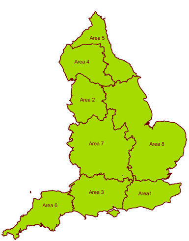
South East (area 1)covers Surrey, Kent, West Sussex, East Sussex, London Boroughs of: Hillingdon, Hounslow, Richmond upon Thames, Kingston upon Thames, Merton, Sutton, Croydon, Bromley and Bexley.
Lower North West (area 2)covers Lancashire (excluding a small area north of the A65), a small part of Cumbria south of the A65, part of North Yorkshire (including Craven), part of West Yorkshire (including Bradford, Calderdale and Kirklees), Merseyside, Greater Manchester, Cheshire, parts of Staffordshire, Derbyshire and South Yorkshire in the Peak District National Park, as well as parts of north west Derbyshire that border the National Park.
Central Southern England (area 3)covers South Gloucestershire, Bristol, part of Somerset (excluding West Somerset and Taunton Deane), Wiltshire, Berkshire, Dorset, Hampshire and the Isle of Wight.
Upper North West (area 4)covers part of Cumbria (excluding most of the area around Carlisle north of the A595/A69 and a small area south of the A65), part of Northumberland (south of the A69), part of County Durham (including Teesdale, Wear Valley and Derwentside), part of North Yorkshire (including Harrogate, Richmond and the part of Craven district that is within the boundary of the Yorkshire Dales National Park) and a small part of Lancashire north of the A65.
North East (area 5)covers part of Northumberland (excluding the area south of the A69), part of Cumbria (north of the A595/A69), Newcastle-upon-Tyne, North Tyneside, South Tyneside, Darlington, Gateshead and Sunderland, part of County Durham (including Chester-le-Street, Durham and Sedgefield), Cleveland and part of North Yorkshire (including Hambleton, Ryedale and Scarborough).
South West (area 6)covers Cornwall, Devon and part of Somerset (including West Somerset and Taunton Deane).
West (area 7) covers Shropshire, part of Staffordshire (excluding that part within the Peak District National Park), part of Derbyshire (excluding that part within the Peak District National Park), Herefordshire, Worcestershire, West Midlands, Warwickshire, Leicestershire, Gloucestershire (excluding south Gloucestershire), Oxfordshire, Northamptonshire and Buckinghamshire.
East (area 8)covers part of North Yorkshire including York, West Yorkshire (excluding Bradford, Calderdale and Kirklees and that part within the Peak District National Park), East Riding of Yorkshire, Nottinghamshire, Rutland, Lincolnshire, Norfolk, Cambridgeshire, Suffolk, Bedfordshire, Hertfordshire, Essex, London Boroughs of: Ealing, Harrow, Brent, Barnet, Enfield, Haringey, Waltham Forest, Redbridge, Barking, Dagenham and Havering.